Digitization of Maps in GIS MAP Service in Rawalpindi Islamabad Pakistan Please Contact 0331_5214562
Image data gaining from Google Earth and Geo referencing in Arc map with original coordinates, With the help of Vector data GIS Map Service in Rawalpindi Islamabad Pakistan Digitalis map through Line, Rectangle, Circle, Ellipse For GIS MAP all type of Geo Referencing techniques for digitalis data these shapes are functioning as like Geometry shapes and we can gaining these shapes parameters and values according to sizes.
Town Planning:
Arc map GIS help in the field of town planing and plot designing With Road Canal and Landscaping Designs. First Step Planning in GIS Arc map. With the help of GIS Map Service in Rawalpindi Islamabad Pakistan completed any project of town planning and city area. Every thing in any city or town we can locate and boundary area manage with the vector data sets uses, remember that there is first step drawing created in GIS service in Rawalpindi Islamabad Pakistan and at all the process of planning. Water pumps and Electricity pools are also showing in the maps with the help of symbol and color legend. For building work use Revit and For Road Designing use Civil 3d.
Topography:
Topology is another unique feature of topography. When two layers are created at a same place At top layer rule is apply with the help of topology. In GIS Map Service in Rawalpindi Islamabad Pakistan We use topology feature for this purpose, First we created data set of database in separate folder. Data set based on two feature classes minimum whose are intersect to each other So with the help of GIS Map Service in Rawalpindi Islamabad Pakistan created topology from this data set launch at map.
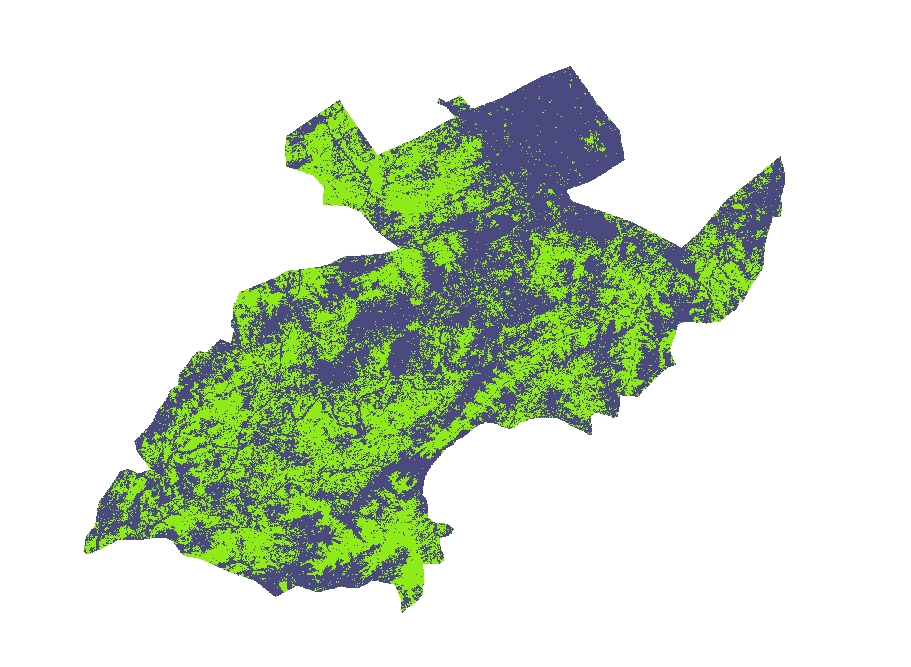
Remote Sensing:

The data receiving from satellite or web and georefering it at projection Before working. After this we have the opportunity to complete all the project according to available information. From Satellite gaining data in the form of raster data set which contain in band sets, GIS Map Service in Rawalpindi Islamabad Pakistan have much of functional tools whose are uses for concerting in contour map and mosaic map even masking option also available. These raster data set presented in two colors one color in tint and other is in shaded one shows the height elevation area and other show slopes and down area, GIS Map Service in Rawalpindi Islamabad Pakistan help to gain fully vegetarian area identify , population index, water index, For this purpose data set of color bands uses.
Geo Coding and Addresses:
Every Vector has his own specification point according to coordinates. In the behalf of this Position point Address can be made and as needed we can find out the position of object. Addresses created along GIS Map Service in Rawalpindi Islamabad Pakistan taking few steps if there is vector data uses we can findout xy points related center of polygon and circle, Line or point. First make the geo addresses and then applying the address so now we have the Goe Coding option GIS Map Service in Rawalpindi Islamabad Pakistan to find address with flash points.
Symbology:
Symbology means symbol of object as like tree, Vehicle, Building, Water etc. Show at the project and map Every symbol its own meaning according to color and map nature with text or annotation style. These symbols are very help for GIS Map Service in Rawalpindi Islamabad Pakistan related any field. Legend of these symbols clear the existence of symbol in the map, these symbols are applicable for point vector data set at the other hand polygons are help full with hatching and gradient color of object. polygons hatches also shows in Legend of map. There is option of 3ds symbols e.g.3ds building, 3ds trees, or 3ds Vehicle different categories are uses in 3ds form uses in arc map and arc scene.
Contouring map:
Contouring map can be generated with the help of point data and elevation level of surfaces. Contouring shows rise and slope of site area, Annotation and Labeling are displaying the contour levels and contour lines offset. If there is GIS Map Service in Rawalpindi Islamabad Pakistan then we can easily contour map create with the help of raster data set. Raster data set created base tin, Tin shows the different levels of surface and area with color specifications according to levels ranges. These ranges according to elevation and level based. Profile view also created with line. This line must at surface levels. this function is GIS Map Service in Rawalpindi Islamabad Pakistan turning impact at map and project. For this purpose 3d editor can be use and arc scene extension but not must at any restricted one.
3D Analyst :
This is Extension of Arc map. in 3d Analyst Extrude the vector data according to height of element, Lines and point levels of elevation accurately visible at screen and raster data set can be created. This is the part of Arc Scene and Arc Scene is the part of GIS Map Service in Rawalpindi Islamabad Pakistan For this purpose we have the option of move to z axis as well x or y axis. This option help us to adjustment of elevation levels of vector data and shapes. But remember that there is no option to uses of 3ds symbols.
Important Point Data.
GIS Map Service in Rawalpindi Islamabad Pakistan has another important feature of import of data in arc map or arc-scene at that sense we can import data from excel to arc map or from CSV file to map. Main thing is that description of points must be exist. X position and Y Position common part of point so it is needed. The file imported in arc map is not usable for mapping, for this purpose this file converted in suitable file formats for use. If there is ranking values it can present with statistically shapes.
Attribute Table.
There is everything in Attribute table related GIS Map Service in Rawalpindi Islamabad Pakistan and all the layers whose are created in Arc Catalog. All the elements of layers are created automatically in Attribute table of layer. Every modifier has separate line and number with ids. In that condition refers and export to excel and any other suitable software. Polygon Area created, Road or Poly line length created and taking any dimension for any purpose.
Base Map.
Some type of base maps available in GIS Map Service in Rawalpindi Islamabad Pakistan online resource use for this purpose. The Esri website have some type of base map data download that data and adjusted related coordinate system uses in world wide carefully according to world map specifications. Maximum data in Degree minute second formats.